Herewith, we submit a response report on the occurrence of earthquakes in East Lombok, NTB based on information obtained from BMKG, Jakarta and analysis of the Center for Volcanology and Geological Disaster Mitigation as follows:
- EARTHQUAKE INFORMATION
On this day, Sunday, August 19, 2018, there have been six earthquakes:
- the first earthquake occurred
at 11:06:13 WIB, with the epicenter at the coordinates of 8.29 South Latitude
and 116.62 East Longitude with magnitude 5.4 S.R. at a depth of 10 km, it is 25
km northeast of East Lombok, NTB.
- The second earthquake occurred 4 minutes later at 11:10:22 WIB with the epicenter at coordinates 8.24 South Latitude and 116.66 East Longitude, with a larger magnitude of 6.5 S.R. at a depth of 10 km, it is 32 km northeast of East Lombok.
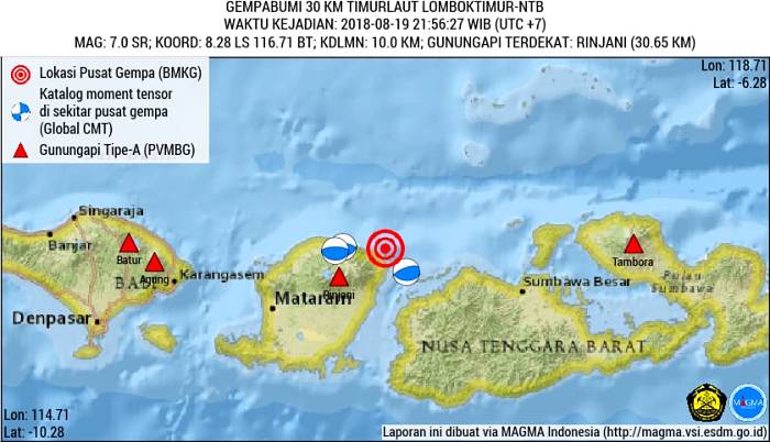
- The third earthquake occurred at 21:56:27 WIB with a central location at 8.28 South Latitude and 116.71 East Longitude (30 km northeast of East Lombok), a depth of 10 km, with a magnitude of 7.0 S.R.
- The fourth earthquake occurred at 22:16:37 WIB in the location of 8.35 South Latitude and 116.51 East Longitude (18 km northwest of East Lombok), a depth of 10 km, with a magnitude of 5.6 S.R.
- The fifth earthquake occurred at 22:28:59 WIB at the location of 8,30 South Latitude and 116,56 East Longitude (23 km northwest of East Lombok), depth of 10 km, magnitude 5,8 S.R.
- The sixth earthquake occurred at 23:25:00 in the 8.50 South Latitude coordinate and 116.85 East Longitude, at a depth of 10 km with a magnitude of 5.0 S.R.
- Geological Conditions of Earthquake Affected Areas
The epicenter is on land. Most of these areas are composed of sedimentary rocks and metamorphic rocks aged Pre-Tertiary to Tertiary; Volcanic rocks are Tertiary to Quaternary, and alluvium is Resen. In areas that are composed of rocks that have been raised and weathered and the alluvium region is very susceptible to earthquake shocks because it is decomposed, loose, and not yet consolidated, so that it will strengthen the effects of earthquake shocks.
- Causes of Earthquakes
Based on the position and depth of the source of the earthquake associated with the Flores back-arc Thrust zone which is relatively east-west.
- Impact of the Earthquake
BMKG data records the impact of earthquakes in several places, which are described in earthquake intensity on the MMI (Modified Mercalli Intensity) scale, namely IV MMI in North Lombok; IV MMI in Mataram; MMI III in West Lombok, Lombok Tengah, East Lombok and Sumbawa Besar. Based on data recorded at the Volcano Observation Post (PGA) of PVMBG, an earthquake was felt by IV MMI at PGA Rinjani Volcano; III MMI on PGA Tambora Volcano; II MMI on PGA Agung Volcano and PGA Sangeang Api Volcano. The USGS data shows an intensity map that includes a westward radius to the eastern part of Java, while to the east to East Nusa Tenggara. When this report was made this earthquake caused buildings to collapse and fire in the Bugin Island area, Alas Sub district, Sumbawa Besar due to electric short circuit. This earthquake has no tsunami potential.
5 Recommendation
- The community is encouraged to stay calm and follow directions and information from the local government and the local BPBD. Don’t be lured by the irresponsible issues regarding the earthquake and tsunami.
- The aftershocks are expected to be smaller than the main earthquake, but citizen are expected to stay alert
- The citizen is expected to remain in the open and avoid buildings because of the previous earthquake shocks, so the vulnerable buildings collapse.
- Beware of cracks on the surface of the earth and avalanches.
Thus we convey the response of the earthquake in the northeastern part of East Lombok.
Source: Center for Volcanology and Geological Disaster Mitigation, Geological Agency, Ministry of Energy and Mineral Resources


Leave a Reply
You must be logged in to post a comment.