The Krakatau volcano is one of the most violent eruptions of the millennium. The detonations of the eruption were heard up to 5000km radius. His geography has changed a lot in the course of time. Today, only a few fragments of the original island remain. But in 1928, the child of Krakatau (Indonesian Anak Krakatau) emerged from the waves. Since then it has not stopped growing and today it is a very active volcanic cone of 324m of altitude.
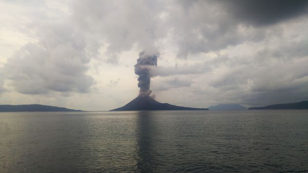
Updated January 2019: The Krakatau has partially collapsed at sea its current size is estimated around 100m
Contents
- 1 The 4 things to know before going on an excursion to Krakatau
- 2 Climbing the Krakatau Volcano
- 3 Hiking and Trekking Krakatau
- 4 Gunung Krakatau (Krakatoa)
- 5 The Eruptions of Krakatau
- 5.1 Historical time of Krakatau
- 5.2 First Eruption of Krakatau Recorded in 416
- 5.3 The Geography and eruptions of the Krakatau between the 9th century and 1883
- 5.4 Krakatau: Eruption of 1883
- 5.5 Map of the areas flooded by the tsunami generated by the eruption of Krakayau in 1883
- 5.6 Map of travel time of tsunami wave triggered by 1883 Krakatau eruption
- 5.7 Map of Krakatau after the 1883 eruption
- 5.8 Why was the eruption of Krakatau so massive?
- 5.9 What is the cause of the violent explosions of Krakatau in 1883?
- 5.10 Why did the eruption of Krakatau cause such a devastating tsunami?
- 5.11 Illustrated World Article of 29 September 1883 on the eruption of Krakatau
- 6 Birth of the New Krakatau “Anak Krakatau”
The 4 things to know before going on an excursion to Krakatau
How to go to Krakatau volcano?
To go to the volcano of Krakatau, there are two options either from Anyer or Carita on Java, very accessible from West Jakarta or Kalianda on Sumatra, accessible from Bandar Lampung or from Bakauheni ferry terminal connecting Java and Sumatra.
Go to Krakatau from Java
We are not going to make you a chapter on how to go to Jakarta? From Jakarta, take the toll road towards Merak. You have several options:
Exit at Cilegon and follow the bumpy road (The roads are improving fast enough in Indonesia right now) to Anyer and Carita exit at Pandeglang and head towards the coast at Labuhan. Then follow the north road to Carita and Anyer. The first option is easier to navigate, but the second option has better roads.
From Carita, there are several boats going to Krakatau.
For Accommodations there are several options in Anyer and Carita. Carita is a lot cheaper.
Go to Krakatau from Sumatra
Bandar Lampung has Raden Inten II Airport with domestic connections to Jakarta-Soekarno-Hatta, Bandung, Yogyakarta, Semarang, Batam, Palembang and Bengkulu (see tiket.com)
To go to Kalianda, take a DAMRI bus to Bandar Lampung (if you come from java) and to Bakauheni if you are coming from Bandar Lampung and get off at Kalianda. Then go to Canti Harbour and take a boat to Sebesi.
For accommodation several options in the region of Kalianda.
When to go to Krakatau?
The best time is from May to October, which corresponds to the dry season, April and November are a little more rainy. From December to March it will depend on the condition of the sea.
See here Climate and rainfall of Java
Is there a permit to go to Krakatau?
The permit will normally be arranged by your boat captain.
There is a Water Source in Krakatau?
No source of fresh water on the islands. You have to provide enough for your drinking water, your water for cooking (it’s not a good idea to cook rice noodles or pasta with sea water!) As well as fresh water for your little toilet.
Climbing the Krakatau Volcano
There are several companies offering day trips from the resorts of Carita and Anyer on Java or Kalianda on Sumatra. It is much cheaper to rent a boat on the Sumatra / Sebesi side but it takes a lot longer to arrive from Jakarta. From Carita, it takes about 1.5 hours by speedboat to reach the island group of Krakatau. The usual approach if you set foot on Anak Krakatau, is to sail between the impressive cliff of Rakata Island and Anak Krakatau and dock on a small sandy beach at the back of Anak Krakatau . There is a forest desperately trying to grow at the foot of the volcano, but only a few meters beyond, all you will encounter is black volcanic rock and sand.
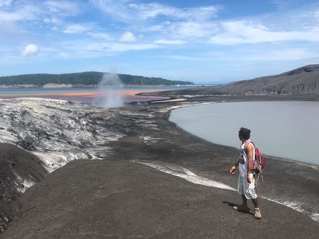
The top of the Anak Krakatau can be very dangerous, especially if the volcano is in activity. Frequently the volcano ejects bombs (large fusions or very hot rocks) that can easily reach the small forest at the beginning of the hike. However, during calm phases, you can climb to the top of the crater. It takes a little less than 2 hours to reach the summit. There is a fairly flat ridge with beautiful views of Rakata Island and other surrounding islands. From here you can also admire the black and steep volcanic cone and watch the sulphurous gases rise from the ground.
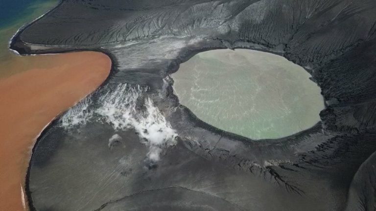
Beyond that, it is dangerous, but it is possible to climb on the crater itself, if the Krakatau is very calm. It’s a steep black sand slope, so very exhausting and difficult to climb … 3 steps forward for 2 steps back, if you’re lucky, and you do not go 3,4 or 5 steps back. There is often a lot of sulphurous gas and the black sand is hot. For those whose attraction and excitement the Anak Krakatau is stronger than the fear and prudence that breathes our spirit. From the edge of the crater, the views are incredible, especially on steep cliffs. the neighboring island of Rakata, which is 813m high, is the highest remnant of the original island of Krakatau, all the rest is under water. The crater of Anak Krakatau itself really looks like the devil’s cauldron! The bubbling mud, thick gases, hideous rock walls and a narrow, slippery crater rim make it a terrifying but fascinating place to explore.
Small note, considering the activity of this volcano at the time you read this, the summit may already be completely different, which even knows the island can radically change (after all less than a century ago, it no longer existed and a century and a half ago, the island was huge, wooded and high.
Note: This just happened again on December 22, 2018 when the volcano collapsed at sea, causing the deadly tsunami of the Sound of the Probe on December 22, 2018.
In condition of the Krakatau’s unpredictable activity, you can descend very quickly to get “safe” (it’s almost like a landslide or running down a powder slope) and back on the boat in no time. There are good places for lunch, camping, swimming and diving on the surrounding islands. Pulau Sertung probably offers the best view of the volcano. If you are lucky during the trip, you will also encounter many monitor lizards and flying fish.
Hiking and Trekking Krakatau
- Duration : 3 Days
- Price : Starting from IDR 5.000.000
- Level: 2/5 (1 being the easiest and 5 extremely difficult)
The highlights of the trip:
- Attend the birth of the earth
- Panoramic view of the Sunda Strait with the neighboring islands.
- Trek on one of the most dangerous volcanoes in the world
The hiking and trekking of Krakatau with Go-Volcanoes, happens as follows:
Detailed Program and Itinerary
1st Day: Your arrival to Jakarta – Carita
You will be greeted by your guide upon your arrival in Jakarta (airport or other) and you will head for the beach of Carita. Lunch at Carita then hike / trekking at Curug Gendang waterfall. Then return to Carita. You will sleep and dine at Villa Mangris. (link to opinion)
Accommodation : Mangris Villa
Meals included : Lunch and dinner
2nd Day : Carita – Krakatau
Breakfast at the hotel. Transfer to the marina harbour to cross the Strait of Sunda to Anak Krakatau by speed boat (about 1 hour, depending on weather conditions) Arrival at Anak Krakatau where you will climb. Then have lunch on the beach. Then you will sail to the island of Sertung where you will camp at night, free time for the beach, snorkeling, dinner at the campsite.
Accommodation : Tent (1 tent for 2 person)
Meals included : Breakfast, lunch, and dinner
3rd Day : Krakatau – Carita – Jakarta
Breakfast at the campsite. Free time for the beach and snorkeling. Return to Carita for lunch. Shower in Carita. Then transfer to Jakarta.
Contact us for more information and reservation.
Gunung Krakatau (Krakatoa)
Gunung Krakatau, Krakatao or as poorly transcribed in Western literature Krakatoa. In this article we will use the Indonesian name, called Krakatau.
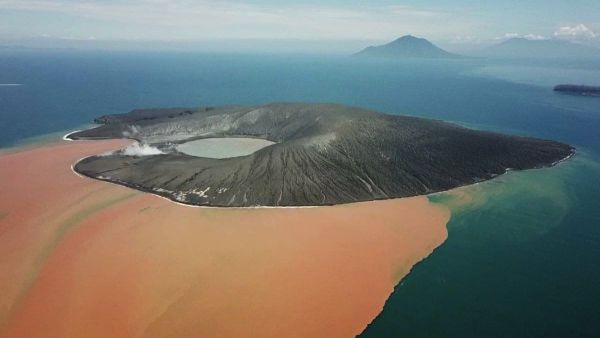
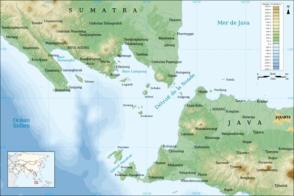
The Krakatau, located in the middle of Sunda Strait, between Sumatra and Java, about 40 km from the coast. Huge crater of more than 8 km in diameter, mainly underwater, whose visible parts form 3 islands: Rakata island, Sertung island, and Panjang island. Since its catastrophic eruption of 1883 which made 36417 victims (according to the Dutch colonial authorities of the time), the Krakatau remained silent until the appearance, in 1927, of a terrible new child, Anak Krakatau. This new island, in the heart of the other three, is in fact only the lava dome that irreparably inflates in the center of the giant crater. Currently, its altitude already exceeds 300 meters for three to four kilometers in diameter, and it counts anger almost annually. It is the world’s most famous volcano: it is estimated that more than 8000 articles have been published about it. On August 29, 1983, Indonesia for the first time officially commemorated the centenary of its catastrophic eruption.
Map of Krakatau and Sunda Strait
The Eruptions of Krakatau
Historical time of Krakatau
The geography of Krakatau has been upset several times
In historical times, the Krakatau volcano was a circular island of 11 km in diameter and 2000m altitude. A cataclysmic eruption destroyed the entire volcanic cone, (perhaps the 416 eruption that destroyed the land bridge between Java and Sumatra, according to the ancient Javanese chronicles, or a much older eruption) leaving only 3 small islands of a few dozen meters high. (today called Sertung, Rakata kecil and Panjang)
First Eruption of Krakatau Recorded in 416
The date of the first historically documented eruption for Krakatau is debated. It is usually dated 416, but the date of 535 is sometimes proposed. The Book of Kings “Pustaka Raja Purwa”, a Javanese chronicle written in the sixteenth century, records that in the year 338 of the Saka era, or 416 of the Gregorian calendar:
“A thunderous sound was heard from Batuwara Mountain (today called Pulosari). The whole earth was mightily shaken, a total darkness, violent lightning and storms. Then came a furious gale of wind, torrential rains and a deadly storm darkening the whole world. A great flood came from Batuwara Mountain and spread east to Mount Kamula (now called Gede). When the waters receded, one could see that the island of Java was divided in two, creating the island of Sumatra. “
It should be known that in the eastern part of the Sunda Strait, the maximum depth is only 20 meters and about 20km wide (which makes the hypothesis of the Javanese chronicle on the separation of Java and Sumatra very plausible) . It is not an easy strait for navigation, with many sandbanks and powerful tidal currents. It has been an important shipping route for centuries, especially when the Dutch East India Company moved its goods from the Maluku Islands (mainly cloves and nutmeg) to Europe or India. Today, its narrowness, shallow depth and lack of maps have led the Strait of the Sunda to be abandoned in favor of the Strait of Malacca, between Sumatra and the Malay Peninsula. (To this information, it is better understood why in the article of the “Illustrated World” below, the journalist and the colonial authorities of the time are worried about navigation in the strait).
The Geography and eruptions of the Krakatau between the 9th century and 1883
Later volcanic activity will resume, giving birth to the volcano Rakata (830m altitude for a diameter of 5km). Then to a second volcanic cone called Danan (450m above sea level) which was sold to Rakata. Finally, to a third volcanic cone Perbuatan (120m above sea level) which is welded to the other two (see map of Krakatau before the eruption of 1883 below).
The island of Krakatau is 9 km long and 5 km wide.
Between the 9th and the 16th century there are 7 major eruptions of the Perbuatan volcano.
In 1680, a very violent eruption accompanied by a tidal wave caused a large number of casualties. (this eruption has been reported in religious chronicles).
From 1680 to 1883, during 203 years no activity. The island is entirely wooded and uninhabited. It is visited only by sinners and woodcutters.
Krakatau: Eruption of 1883
Map of Krakatau before the 1883 eruption
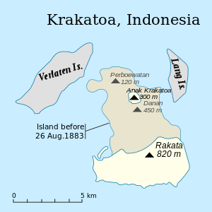
- Sertung corresponds to the Dutch name of Verlaten
- Rakata Kecil is the Dutch name for Lang
Chronology of the Krakatau eruption
- From April 20 to May 10, 1883: Violent seismic crisis in South Sumatra and West Java (but at this time there is no link between this seismic activity and Krakatau).
- May 10-19, 1883: The earthquakes intensify causing damage and victims.
- May 20, 1883: After 203 years of sleep, eruption of the small volcanic cone Perbuatan, the sound of the explosion is perceived within a radius of 160km! The height of the eruptive plume reaches 13000 meters. The shockwave stops all the clocks until Jakarta (name of the colonial era: Batavia)
- May 26, 1883: Volcanic activity decreases in intensity. During three days, the height of the eruptive plume stagnates between 1000 and 1500 meters of altitude. Taking advantage of this lull, maritime excursions are organized around the Krakatau.
- May 27, 1883: The Dutch mining engineer Schurman arrives on the island of Rakata / Krakatau (We owe him the first scientific report of this eruption) and declares that there is no longer a leaf on the trees and that 60 centimeters of basaltic black ash cover 30 centimeters of very clear pumice (dacitic). This observation was the starting point for the explanation of the terrible eruption that will follow.
- From May 29 to end of June 1883: recovery of the explosive activity with a height of plume of about 5000 meters.
- July 1, 1883: brutal recrudescence in explosive violence. The eruptive column rises to 18,000 meters then gradually decreases until August 10 when it reaches barely 1,000 meters. During this period, fragments of pumice fall back to 1900 km west of Krakatau. There is a permanent halo around the sun, the moon turns blue.
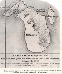
- August 10, 1883: a captain of the topographic service of the Dutch army, Ferzenaar will be the last person to land on the island of Krakatau. He declares: “All the branches of the trees are broken, the thickness of ash reaches 2.5 m and we perceive some small explosions on the Danan volcanic cone”.
- August 11, 1883: brutal awakening of the Danan volcanic cone. 11 eruptive chimneys simultaneously enter into activity and project their plume to some 6000 m of altitude. This activity will continue until August 26th.
From this date, the reconstruction of the following events is largely based on recordings of measuring devices, volcanic deposits and the testimony of some captains of boats crossing the Sunda Strait or sailing near the coast. from Sumatra (south of Bengkulu) whose boat did not sink! Because no one living near the volcano has survived.
- August 26, 1883:
- At 10:00, the eruptive column reaches 11,000 meters.
- At 13:00, it rises to 21,000 meters.
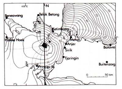
- At 15:00, 26,000 meters. In the space of 7 hours, a 27 meter layer of ash will fall on the small neighboring island of Sertung (6 centimeters per minute).
- August 27, 1883:
- at 5.30 am, the series of huge explosions that will be seen in a radius of 3000 km begin.
- at 7:00, the eruptive column reaches 43,000 m in height.
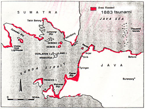
- At 9:58, the largest of all the explosions occurs, which will be seen in a radius of 5000 km, where the noise will arrive a little more than 4 hours later. (If this same explosion took place in Paris, it would have been heard both east of Quebec, Kazakhstan or Ivory Coast). The shock wave is so powerful that all the windows shatter within a radius of 500 km, it will travel around the world 7 times! This colossal explosion is accompanied by a huge tidal wave (Tsunami). The height of the wave crashing on the coast of Java and Sumatra, the height is estimated at 47 meters. This huge wave will take 2 hours to reach Batavia the capital (Jakarta today). A gunboat, the Berouw, with 10 crewmembers will be found 5 km inland from Sumatra after climbing over a 15 m hill (see map of tsunami affected areas below). krakatau from 1883). It was noticed, a few days after the eruption, an abnormal rise of waters at Mont Saint-Michel (see books of the town hall, index of the tide of the year 1883).
- The height of the volcanic plume reaches 48,000 m. Darkness is total within a radius of 400 km. Pyroclastic flows of pumice and incandescent ash fluidified by the gas move on the surface of the sea over long distances (some 170 km for some) at a speed of 360 km / h or 100m / s. The ashes released by the volcano fall on an area of 700 000 km², the largest fallout area ever recorded. The finest ashes are orbited around the planet and will take more than a year to fall.
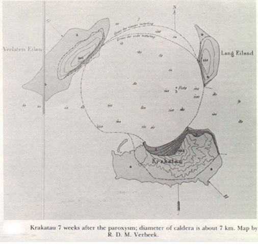
- 14:30, the night is now total within a radius of 600 km around the eruptive center. 4/5 of the area of the island of Krakatau have disappeared. There is nothing left of the Danan and Perbuatan volcanoes and only the eastern part of Rakata. In place of the collapsed island now opens a caldera 290 m deep, under the sea.
- At 16:00, the eruption decreases, the height of the eruptive plume is only 25,000 m.
- August 28, 1883: it is the end of the eruption that lasted 39 hours. The balance is heavy. 40,000 victims, hundreds of villages destroyed. The volume of material expelled by the volcano was 20 km3. The energy developed by this eruption corresponds to 100,000 bombs of Hiroshima.
Map of the areas flooded by the tsunami generated by the eruption of Krakayau in 1883
Map of travel time of tsunami wave triggered by 1883 Krakatau eruption
Map of Krakatau after the 1883 eruption
Why was the eruption of Krakatau so massive?
What is the trigger for an eruption of such intensity?
We must remember the observation made by the Dutch mining engineer Schurman: “60 centimeters of black basaltic ash covers 30 centimeters of very clear pumice (dacitic). “
This proves that the volcano was made up of very different compositions. It is therefore likely that an intrusion of very hot basaltic magma occurred in the reservoir or magma chamber filled with less hot dacitic magma. Viscosity and different temperature, the convection was instant where the enormous mixing in the tank, with accelerated degassing and the enormous pressure that results. When the phenomenally increasing pressure exceeds the resistance limit of the tank roof, the tank fractures and explodes. The sea then rushes inside the magma reservoir at 1300 degrees. The colossal eruption called “phreato-ultraplinian” starts. Instantaneous vaporization of the mixture of sea water and highly explosive magma. The explosions perceived within a radius of 5000 km are the emission of several atomic plumes of ashes and pumices, breakers called “fiery clouds” which will orchestrate this natural disaster.
The 4/5 of the island are gone. It did not explode as originally thought but it sank in the waves. The roof of the magma reservoir has collapsed creating a caldera 10 km in diameter under the sea.
What is the cause of the violent explosions of Krakatau in 1883?
The final explosions of very strong intensity were probably caused by the penetration of seawater in enormous quantity in the magma chamber. This mixture of seawater and magma is highly explosive.
Other, less intense explosions could also be caused by the interaction of pyroclastic flows with seawater.
Why did the eruption of Krakatau cause such a devastating tsunami?
The tsunami is due to the compression wave that followed the explosion caused by the penetration of large quantities of seawater inside the reservoir and the fall in the sea of the northern half of the Rakata volcano that was reaching 860 m above sea level. Several cubic kilometers of rock have thus penetrated the waves in a few moments accompanying the formation of the underwater caldera.
Illustrated World Article of 29 September 1883 on the eruption of Krakatau
(The sentences in parenthesis, in italic and green, are my own comments)
The Disaster of Java
In the last days of August, a terrible cataclysm occurred in Batavia (former name of Jakarta and its region) and in the surrounding cities.
Batavia is, as we know, the capital of the island of Java, in Oceania (It is interesting to note that Indonesia is considered part of Oceania and not Asia). In the western part of this island rise several volcanic mountains. Here, the ground is almost everywhere riddled with openings by which emerge underground steams. It is probable that the pressure of these vapors has become, in recent times, strong enough to bring to the mouth volcanoes of molten lava which will have passed by the craters or cracks which furrow the side of the mountains.
In the night, violent detonations, starting from the volcanic island of Krakatoa, sounded. A shower of stones, lava and ashes fell on the neighboring towns: Soerkata, Serang, Cheribon.
At Batavia the gas went out everywhere, and volcanic gleams were visible all night long. In the morning, the day was troubled by thick clouds; at Batavia the darkness was almost complete. This commotion had unleashed the waters of the Serang River. The bridges were washed away; moreover, a sudden invasion of the sea precipitated the course of the waters.
A village near Auger was completely washed away.
As in all the volcanic countries where the intensity of the underground heat activates the germination, the vegetation of the island of Java is superb. The mountains are covered with wood and cereals. Hills rise where the air is fresh and salubrious.
Doctors send patients to recover in this beautiful region. Crystal clear streams flow everywhere, and the Javanese do not know the vicissitudes of the seasons.
The terrible disaster resulted in the deaths of 100,000 indigenous people and the Dutch Auger garrison who disappeared in the waves. It is in the night of Monday, August 26th that the volcano of Papandayang (Here we speak well of Krakatoa and not Papandayan which is located in the southeast of Bandung, even at the time of the errors crept into the articles of the press) began to fire flames and torrents of lava. On Sumatra were seen three immense columns of fire rising to a great height; the flanks of the volcano from which they arose were invaded by torrents of lava, which flowed far and wide in all directions. A shower of stones fell over a distance of several miles, and the atmosphere was laden with such a mass of dust that the darkness was complete. The cyclone added to this scene of devastation, removing the roofs of houses, trees, men and animals.
Suddenly, the scene changed: The mountain collapsed, and at the point where Papandayan (Krakatoa and not Papandayan) stood, there were seven distinct peaks that vomited by their craters streams of steam and white lava, invading slowly the hillsides formed heaps of fire of a hundred yards in extent.
In Batavia, 20000 Chinese and a few hundred Europeans perished in the lower city; on this side of this splendid city, no trace of the European quarter remains. At the governor’s palace, which is in the upper town, the roof collapsed under the mass of volcanic mud and three servants were killed. The city of Bantam has been entirely covered by waters; it is assumed that 1200 to 1500 people drowned. In Serang Island, no one has been saved. In Cirebon, although the flood did not do much damage, the fall of rocks and lava caused many casualties.
Birtinzong, Samarang (Semarang), Jogjukerta (Yogyakarta), Sourakerta (Surakarta, also called Solo) and Surabaya – the latter point 500 miles from Sunda Strait, the center of the cataclysm – have suffered greatly. Tumerang was covered with lava, and half of the indigenous population, about 1800 people, perished. Figelenking was almost destroyed. The disasters are also great in Warange, Talatoa and in other points. As for the cities of Telok-Betong. Auger and Tjeringen are no more than a heap of ruins.
Auger was a charming little port, all surrounded by greenery, where one could see on the beach one of the most beautiful banyan trees (multipliers) of the Malay Archipelago. Its branches formed a dome more than 50 meters in diameter at the base.
From the hydrographic point of view, the one that worries the navigators the most; the course of the strait seems entirely upset. We can judge by the following description:
The Strait of the Sunda is 70 miles long (the distance is 1862 meters). Its entrance from the southwest, that is to say, on the side of the Indian Ocean, is 60 miles wide, but on the side of the China Sea the strait narrows a lot and is now only 13 miles, about 20 kilometers. About the middle of it, at an equal distance from the coast, was a group of three islands, the largest of which, Krakatoa, was five miles long and three broad. Its volcanic peak, 699 meters above sea level, was an excellent point of recognition.
Krakatoa was difficult, arid and uninhabited; the officers who did the hydrography did not find a trace of fresh water, but they recognized on its north-east coast a hot spring where the thermometer marked about 68 degrees centigrade. On the Panjang Island, which was separated from Krakatoa only by a channel a few hundred meters long, animal life was represented by a very small deer species and wild pigs. Between Krakatoa and Java, the bottoms were unequal, but the channel presented no danger; on the side of Sumatra, there were rocks and several islands, the highest of which, Poulo-Bezee, was remarkable for its very sharp peak, 860 meters high, that is to say, higher than the volcano of Krakatoa.
The fourteen volcanic islands that have emerged from the waters are on the line that connects Hog Point, located 12 miles from Lampong Bay, where was the destroyed town of Telok-Betong, at Point St. Nicholas, the northernmost point of Java; they are therefore in the narrowest part of the strait, that which is scarcely more than 20 kilometers wide, almost at its mouth to the seas of China.
One of the Indian Council members left Batavia, with full powers to distribute relief to the survivors of Bantam District. The Dutch Navy Minister has ordered Batavia to send cruising warships to the entrance of the Sunda Strait, to warn the many ships coming from the Indian Ocean that navigation is dangerous in these trimmings. It is to be feared, in spite of all the precautions that will be taken, that we have to register numerous maritime losses; it will certainly be necessary to cross for a few months surveillance vessels, in order to warn navigators who are at sea of the hydrographical upheaval of the passage they intended to take to enter the seas of China. The English Admiralty has just detached from its Chinese squadron three warships, the Champion, the Maypie, and the Flyingfisch, which have the right to reconnoitre the Straits of the Sunda.
In Amsterdam, The Hague and the main cities of Holland, committees are being formed to help the victims of this disaster.
Birth of the New Krakatau “Anak Krakatau”
After this famous day of August 27, 1883, no fumarolic or explosive activity took place during 44 years.
- December 29, 1927: first manifestation of an underwater eruption at the site of the former Perbuatan volcano.
- January 26, 1928: Huge sprays of black ash come out of the sea and rise several thousand meters high.
- February 1928: A new island emerges, the Anak Krakatau or the child of Krakatau.
- 1933: the new island is ring-shaped, its height is already 67 m.
- 1941: it is now 139 m high.
- From 1941 to 1950: succession of constructive and destructive phases. The volcano will reach 160 m before returning to 129 m altitude.
- From 1950 to 1960: a second cone begins to rise in its vast crater.
- Until 1988: its explosive activity will be almost constant with lava flows that consolidate its base.
- From 1988 to 1992: the activity stop.
- November 1992 to 2002: explosive activity resumes with a fantastic lava fountain and several pours. Regular explosive activity continues until 2002.
- 2007 to 2012: Krakatau’s volcanic and explosive activity resumed and was fantastic with deafening “booms”, repeating lava fountains, basalt blocks or deformed lava flows more than 500 m around the crater.
Leave a Reply
You must be logged in to post a comment.