Note: The Merapi has entered a new eruptive phase, no climbing activity of the Merapi can be achieved. You can instead climb the Merbabu, from where you will have an unparalleled view and observation point of the Merapi.
Merapi (2911masl), is located in the center of Java, near the city of Yogyakarta. It is the most important of the Javanese volcanoes and the most dangerous, according to the volcanologist.
But you wonder: How to climb the Merapi and reach its summit? Where to start? How and when to go to Merapi? How much does it cost to do the Merapi trek? Where to find guides? What are the most important mistakes?
How is the climb going? what are its stages? Many unanswered questions!
The purpose of this article is to give you all the information you need to climb the Merapi and the mistakes to be absolutely avoided.
Then, for those who do not want to have the least hassle and who want to delegate, to the Go-Volcano, the organization and logistics of the trek, you will find the program and all the corresponding prices.
Finally, for the curious, at the very end of the article we will talk about the Merapi volcano, the beliefs and legends that surround the volcano. As well as its eruptions and its volcanic activity.
Contents
The 7 things to know before climbing the Merapi Mountain
How to go to Merapi?
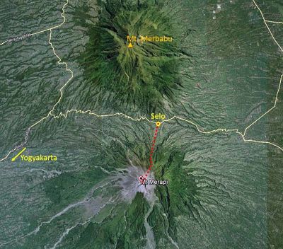
The Merapi is accessible from the village of Selo. Selo is accessible from Yogyakarta which has an international airport, but also from Solo (Surakarta).
How to go to Selo?
From Yogyakarta
Once in Yogyakarta, it is quite easy to find a transport to go to the mountain village of Selo, from where the Merapi ascension begins. A vehicle with driver can be chartered. It is strongly recommended to bring your driver the next day, as it can be difficult to arrange transportation from Selo. The journey takes about 2 hours (it depends on the traffic).
From Surakarta (Solo)
Solo is also a little less than 2 hours drive from Selo.
When to go to Merapi?
The climbing activities of Mount Merapi are usually open throughout the year. But in some conditions such as an increase in volcanic activity, the climbing activities will be limited to Pasar Bubrah or even totally closed for climbing activities.
Is there an entrance fee and how much?
- Foreign Tourist : IDR 150.000/person/day
- Local Tourist : IDR 15.000/person/day
Where to Sleep?
Selo has very few lodging options. You can stay in the vicinity of Yogyakarta or SOlo, which has more lodging options ranging from Dormitory to 5-star Hotels.
Is it necessary to use a guide?
Hiking and trekking in Mount Merapi is very safe to do without using the services of a guide.
Where to find guides and porters?
Guides and porters can be found directly at Selo.
What to do around Yogyakarta?
It is a tourist region, and it is the center of the Javanese culture with different sultanates and Kraton (Palace), the most famous is that of Yogyakarta. You will find the Hindu temple of Prambanan and one of the largest Buddhist temple in the world, Borobudur.
But there are also several volcanoes in addition to the most watched and most dangerous of all the Merapi, Merbabu, Sindoro, Sumbing and Dieng plateau a magnificent volcanic plateau located between 1500 and 2000m.
There are also beaches activities on the Indian Ocean.
Ascension of Merapi Volcano
There are two routes to the summit: New Selo in the north and Kaliurang in the south.
Kaliurang is only a few minutes drive from the city of Yogyakarta, but this route is forbidden because too dangerous. Instead, the Merapi base camp is located in New Selo.
Most hikers start at midnight to reach the summit at dawn. Although there are one or two places on the trail where it is possible to pitch a tent, the largest camping area is Pasar Bubrah at about 2,675 m under the cone of the summit which has one or two monuments. It is the ideal place to rest a few hours before dawn, although it is a huge field of blocks without grass.
From the base camp, follow the road for 20 minutes to the big sign of NEW SELO next to some warungs. This place is a very popular point of view for local tourists because you can enjoy great views of Gunung Merbabu through the mountain pass as well as on Selo and the surrounding fertile agricultural area. During the first 30 minutes after the sign, the trail follows steeply the large plantations with a sharp fall to your left. This small path can be very dusty during the dry season, but still offers a lot of grip when going up.
When the last fields are abandoned, you are at an altitude of almost 2,000 meters, and little by little, the forest trees become smaller and more distant from each other. As the wood becomes less dense, the path begins to become more and more rocky. Once past the sign indicating the national park, it will take you about 45 minutes of climb to reach the post 1 (2 150 m) which is closed and protected by big rocks and offers a welcome protection against the winds often very strong.
After 30 to 40 minutes, the summit of the next ridge is reached. The numerous commemorative plaques (2,400 m) recall that the greatest care must be brought to the top of this very active volcano.
From there, the trail is fairly flat for a short distance of 300 to 400 meters before climbing quickly to a new memorial (2011). From there, you are five minutes walk in the middle of a huge block field known as Pasar Bubrah, often filled with tents on the weekends. There are large rocks that can be used as wind shelter, but it is a rather exposed area and camping can be more comfortable – and warmer – lower down the track.
On the right, you should be able to see the twin cones of Sumbing and Sindoro. On the left is a small but harmonious summit that marks the beginning of an alternative route down the eastern side of the mountain that brings hikers to the village of Deles.
From Pasar Bubrah, the steep rocky cone of Merapi is clearly visible above you and it takes 45 minutes to reach the edge of the crater itself. This part is very tiring and it is not uncommon to see people give up halfway. Inevitably, your shoes will also fill with small stones and volcanic sand. As you climb, the view becomes more and more beautiful. To the left (east), you should be able to see the great Lawu mountain that dominates the clouds in the distance.
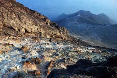
In the end, you will reach an area where you feel that the soil is getting a lot hotter and that in a few areas you will pass several mouths where hot volcanic steam comes out of the mountain. From this area, it will take you about 15 minutes to reach the edge of the crater. The last 100 meters reveal an incredible mountainous world of scree and huge volcanic rock debris created during the huge eruptions of 2010. The smell of sulfur can be overwhelming.
Map of Merapi Climbing Route
Hiking and Trekking of Merapi with Go-Volcano
Hiking and Trekking Merapi 2 Days and 1 night
Detailed Program and Itinerary
1st Day : Jogjakarta – Selo
Arrival at Adi Sutjipto International Airport in Yogjakarta, you will be met by our guide and transferred to the Selo mountain resort at the foot of the Merapi volcano. On the way, stop at Prambanan Temple. Breakfast in a local restaurant. Dinner and overnight at the hotel Selo Pass.
2nd Day : Selo – Merapi Summit – Yogyakarta
Wake up at midnight. Transfer to the start of the Merapi ascent trail and start the hike at 1am. With the objective of the summit at sunrise. Then you will get off at the Pasar Bubrah campsite for breakfast and finally go to the Selo Pass Hotel and have lunch. Then return to Jogjakarta airport or extend your stay in Jogjakarta (Optional excursions can be arranged for Prambanan, Borobudur and other, the area and full of things to see)
Price
Facilities Included
Volcano of Merapi
Merapi literally means “mountain of fire”. It is around this volcano that gravitated the core of the Hindu and Buddhist culture of ancient Java. The Prambanan complex and the famous Borobudur are at its feet where one of the highest densities of population is today.
The Merapi was born 400,000 years ago. This andesitic volcano 28 km in diameter, 2911 meters above sea level, located 26 km from Yogyakarta has been in constant activity since the 6th century with alternating explosive and effusive phases that continually modify its relief and altitude.
Merapi is one of the most dangerous volcanoes in the world. Nearly 300,000 people live in the endangered area. There was a major eruption in 2006 but nothing on the scale of what happened in October and November 2010. Today (2018), the Merapi has entered a new eruptive phase.
Merapi and Its Eruption
Since 10 centuries, 63 eruptions have been recorded, including 23 major ones with many losses in human lives.
- 1672: 3000 victims
- 1931: 1390 victims
- October 22, 1994: 64 victims, many missing and 500 burned
- October 1995: 41 victims and 280 burned
- October 26, 2010 to the beginning of 2011: 353 victims
The activity of Merapi is characterized by the regular extrusion of very viscous lava which accumulates in the form of unstable domes that collapse generating pyroclastic collapses often disastrous (avalanche of blocks and ashes – burning clouds – breaking waves – lahars) . The continuous emission of andesite lava on the surface of the dome is estimated at 300,000 m3 per day.
Often its eruptions are announced by renewed seismic activity or by deformations of the summit but sometimes they also take place without any precursory sign.
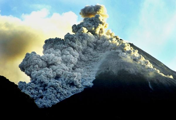
The fiery clouds or pyroclastic flows (local people call it “Wedhus Gembel”) always located on its southwest-south-south-south-east flanks (directly above the city of Yogyakarta) can reach and even exceed a development of 10 kilometers.
“Breakers” oriented in the same directions often reach 10 to 17 km. As for the lahars that remobilize these primary products some can go and even exceed 23 km and reach the city of Yogyakarta (as it happened in the year 2004).
Today the dome continues to grow and reaches an uneven volume since it is measured. Many fractures appeared at the top of the volcanic edifice and in particular on the southern flank testifying to a growing imbalance that could lead to massive collapse.
The magma reservoir of Merapi (probably of gigantic size) is located about 9 km below the summit (this depth was obtained by reasoned interpretation of the seismic waves). It is possible that a shallow magmatic reservoir is located about 1,000 meters below the summit. (The opinion of the volcanologists is divided as to its hypothetical existence). Nevertheless, there is an seismic zone at this depth directly beneath the dome that occupies the active crater.
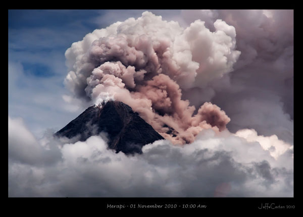
Eruption of Merapi, 2010
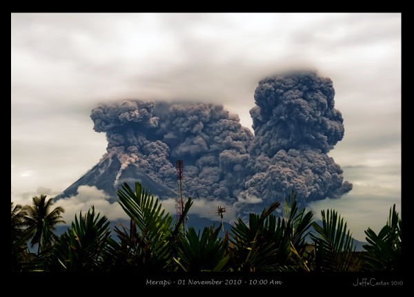
The eruption of the Merapi in 2010 is a volcanic eruption that took place on the Merapi from October 26, 2010 to early 2011. Marked by fiery clouds and lahars, this eruption claimed the lives of 353 people, including Mbah Maridjan, the “juru kunci” of the volcano. For scientists, this is the strongest eruption since 1872.
The previous eruption of the Merapi occurred from March 2006 to August 9, 2007. Typical of the Pelean eruptions, it resulted in the formation of a lava dome, which gave rise to a leaky lava flow escaping crater. Nevertheless, fiery clouds occurred during explosions of volcanic explosivity index of 1. The volume of lava emitted is greater than 4106 m3. Despite the evacuation of threatened populations, the eruption caused several deaths and damage.
After two and a half years of rest, the Merapi shows signs of waking from March 2010, with a swelling of the volcano from 0.1 to 0.3 millimeters per day. This phenomenon accelerates at the end of the summer to reach 1.1 millimeters daily on September 16th, 0.6 centimeters at the end of September, 10.5 centimeters on October 21st and 42 centimeters on October 24th. At the same time, a seismic crisis appears at the beginning of September and the lava dome warms up from the end of October. In addition to these measures, there are phenomena such as an avalanche of debris on September 12 and the formation of a white volcanic plume rising 800 meters above the summit of Merapi. The authorities are then convinced of the imminence of an eruption and raise the alert level to level 2 on September 19th, level 3 on October 21st and level 4, the highest on October 25th. On the same day, they make a recommendation to people within a 10-kilometer radius of the summit, between 11,000 and 19,000 people, to immediately evacuate their villages.
The eruption begins on October 26th at 5:00 pm local time with explosions producing fiery clouds flowing down the west-south-west and south-east flanks. This series of fiery clouds, which last for the most part between two and nine minutes apart from two which develop for 33 minutes, ends at 18:54. These fiery clouds are accompanied by muffled sounds, a volcanic plume rising to about 4,500 meters above sea level and the reddening of the lava dome is visible from the north.
After this first eruptive episode, the activity resumed more vigorously on the night of October 29 to 30 at 1:10. Volcanic ash falling ten kilometers from the volcano and the explosions being louder, thousands of people still living in the evacuation zone flee at night, bringing the number of refugees to 50,000.
On November 3, in the face of the intensification of the explosions, the authorities carry the radius of the evacuation zone to fifteen kilometers around the summit of the volcano. The next day, the explosions continue, gaining even more power. The volcanic plume is eight kilometers high and the many hot clouds sweeping down the south flank are up to nine kilometers long.
From November 18, the eruption diminished in intensity with a drop in seismic activity, the number of hot clouds and the altitude of the volcanic plume reaching between 4.5 and 6 kilometers of altitude. Lahars begin to form on the slopes of the volcano in November 2010. Those of January 3 and 9, 2011 cause destruction, death, injury and evacuations. The volcanic risk scale is lowered to 3 on a scale of 4 on December 4, 2011 and to 2 on January 9, 2011, reflecting the end of this eruption.
The fiery clouds of the first day of the eruption killed 34 people including Mbah Maridjan, juru kunci of Merapi. The latter refused to evacuate his village of Kinahrejo despite repeated requests from the authorities and many people present with him in his house. Thirteen of them were killed instantly with him by the gases and volcanic ash at 1000 ° C from a fiery cloud that destroyed the village. The body of Mbah Maridjan was found the next morning in a prayer position, fulfilling his spiritual role by a team of rescuers. Given the power of the eruption, the evacuation order is fairly well respected, but especially by women, children and the elderly, men preferring to stay to look after their fields or their animals. On November 1, the human toll rose to 38 dead. On November 4, the volcanic ash is released into the atmosphere so that the authorities ask the airlines not to approach more than twelve kilometers from the volcano. Although remaining open, the two closest airports to Merapi see some companies cancel flights.
In total, the number of victims stands at 353 dead on December 3, more than 150 injured and the number of displaced more than 320,000 people on November 8. The authorities estimate the damage cost at Rs 5,500 billion, or 500 million euros, at the beginning of February 2011, and this amount is still increasing due to the lahars.
For the agriculture sector alone, losses exceed US $ 100 million, affecting the livelihoods of local people. Most of the crops destroyed by the eruption are volcanic ash rains: more than 2,500 hectares of crops in the Sleman kabupaten, 5,000 hectares of salak and 100 hectares of rice lost in the Magelang kabupaten, several thousand hectares of crops in Boyolali and Klaten kabupaten. 1,961 heads of cattle died during the eruption.
Since the eruption ended in early February 2011, the destroyed villages are the subject of a black tourism which benefits especially the inhabitants of the affected areas of which some have converted into small sellers.
During the expansion of the exclusion zone on 3 November, the crisis management plans usually used are overwhelmed by the scale of the evacuation: no refugee camp was planned to accommodate the one million people leaving the country. area threatened by intensification of the eruption. Makeshift solutions are in place, such as hosting more than 21,900 refugees at the Maguwoharjo stadium in the Sleman kabupaten; other smaller camps are open around. The eruption of 2010 will have highlighted the need to review the evacuation plans and the measures to be taken at the next alert.
Source : Wikipedia
History of Merapi
- Pre-Merapi (400,000 years ago): only Bibi hill remains.
- Ancient Merapi (between 8,000 until 60,000 years ago): activity characterized by large basaltic effusions and fiery clouds.
- Middle Merapi (2000 to 6000 years ago): large andesitic flows, violent Saint Helens explosion (1980) during which the south-west flank partially collapsed, leaving an iron crater in place horse and a wide depression of 7 × 5 km. It is the magma reservoir located under this flank that has exploded violently.
- Recent Merapi (between 600 and 2000 years): emission of fiery clouds and phreato-magmatic eruptions favored by the vast depression at the summit. Indeed, these eruptions require a large crater to collect rainwater and long periods of eruptive calm to allow these waters to infiltrate in depth. The magma in contact with these layers causes the vaporization of the water and it is the eruption.
- Contemporary Merapi (600 years ago): the increase in the frequency of eruptions then made it difficult to recharge the aquifer and little by little the magma arrived at the surface to form lava domes. We thus witness the alternation of construction of very viscous lava dome and their destruction by explosions that generate fiery clouds. Therefore, the absence of a gaping crater at the top of the volcano makes the phreatomatic magmatic eruptions unlikely.
Typical activity of Merapi
The Merapi volcano has two main types of eruptive activity:
Growth periods – destruction of the summit lava dome
The very viscous magma favors the formation of a lava dome at its exit point. This dome can be unstable and generate avalanches of blocks along the flanks of the volcano. However, the eruption in the strict sense is generally triggered by the injection into a superficial magma chamber (about 1 km deep) of a magma from a deeper chamber (9 km). This magmatic thrust causes the dome to collapse on the surface in the form of fiery clouds.
A fiery cloud (or pyroclastic flow) is a mixture of burning gases, ashes and blocks that run down the slopes of a high-speed volcano, devastating everything in its path. Some are gravitational only, that is to say that blocks fall off the dome that is located in the crater. Others result from an explosion at the dome but their density is such that instead of rising in the atmosphere, they collapse along the flanks of the volcano.
The new magma then arrives on the surface and immediately forms another dome. Its position may be slightly modified compared to the previous dome. This type of eruption is preceded by a sharp increase in seismicity and by the increase of temperature of fumaroles. This cyclical formation-dome destruction activity has been common to Merapi for centuries.
Paroxysmal eruptions that cause the destruction of the dome without it being immediately rebuilt.
This kind of activity suggests that the explosion is not triggered by a supply of new magma. The explosion is most likely to occur when the open-system degassing characteristic of dome formation stops due to obstruction of the exit point. The pressure of the gases increases abruptly in depth until the explosion.
This kind of very explosive eruption was observed on the Merapi in 1768, 1823, 1849, 1972, 1930.
They are characterized by vertical projections which then fall violently on the side of the volcano in the form of devastating pyroclastic flows.
Two eruptive dynamisms: closed system (explosive eruption) and open system (formation of a lava dome).
The eruption of 1930 reached its climax on December 18 and 19, 23 days after the eruption began. Burning clouds swept up to 15 km away and a huge depression opened to the west. This eruption made 1369 victims. An effusive phase began in January 1931, forming a dome in the upper part of the crater, the introduction of which was accompanied by many hot clouds. The activity stopped in mid-September 1931, but important hot lahars started with the rainy season.
There are also periods of rest at Merapi: 1943 – 1952, 1961 – 1967, 1986 – 1990, which generally follow violent explosions and which account for the restoring time of a magma chamber. Their duration varies with the intensity of the eruption that has just taken place.
Eruptive activity of Merapi since 1768
Monitoring and forecasting at Merapi
From the 60 small Indonesian volcanological observatories, 5 belong to the Merapi area. In each of them located in Kaliurang – Bababadan – Ngedos – Jrakah and Selo, three men take turns day and night to monitor the activity of the volcano. Every day, by radio, the observations are communicated to the central observatory based in Jogja – MVO (Merapi Volcano Observatory). This centralizes and analyzes the scientific data which are then transmitted to the Volcanological Survey of Indonesia (VSI) in Bandung.
Merapi is the most complete volcano in all of Indonesia:
- 10 seismological stations
- 16 inclinometer stations (10 at the top – 6 at the base)
- 2 extensometers at the top
- 6 magnetic stations
- 1 gravity network of 20 points
- 1 GPS network of 15 points
- Geochemical measurements (temperature – composition of fumaroles as well as daily analysis of SO2 levels)
The 4 levels of Merapi activity defined by the VSI are as follows:
- Normal – (Normal) 1: Normal level (visual observations and normal seismic data).
- Warning – (Waspada) 2: The seismic data show a recovery of activity.
- Ready – (Siaga) 3: Seismic activity is getting stronger, Earthquake energy is increasing, The eruption is likely, almost certain but in how long? Everyone must be ready to leave at any time.
- Warning – (Awas) 4: The eruption is near (siren), evacuate in an army truck.
In February 1994, 6,000 people were evacuated (for almost 1 month), which considerably reduced the number of casualties.
Leave a Reply
You must be logged in to post a comment.